Leg 44 - From Vignacastrisi to Tricase
Leg 44 - From Vignacastrisi to Tricase
Gps Track
- Start: Vignacastrisi
- Arrival: Tricase
- Total Length: 13,6 km
- Difficulty by Foot: Medium
- Cycle type: Hybrid
- Difficulty by Cycle: Medium
Once you’ve left the town centre of Vignacastrisi and gone past the Chapel of the Madonna of Constantinople, continue straight until you get to a rest area, after which you’ll enter the centre of Marittima.
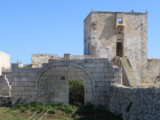
After a series of junctions, where you need to take care, cross the provincial road and head towards the church of the Madonna dell’Attarico. Carry straight on and pick up the unpaved road that will take you near to the ruins of the Sasso Tower, looking out to sea. Moving on, you’ll come across a forest of eucalyptus trees, pines and Vallonia oak trees, typical of this area. Lastly, you’ll come to a crossroads indicating the port of Tricase, but the Via Francigena heads towards the town centre, located in the hinterland. This leg of the journey ends in Piazza Pisanelli in Tricase, which can be recognised thanks to the Gallone Princes’ castle.
- Leg 38 – From Torre Santa Sabina to Brindisi
- Leg 33 – From Bari to Mola di Bari
- Leg 38 – From Serranova to Brindisi
- Leg 10 – From Itri to Formia
- Leg 09 – From Fondi to Itri
- Leg 01 – Variant of Caffarella – From Roma to Castel Gandolfo – 26,5 km
- Leg 12 – From Minturno to Sessa Aurunca
- Leg 07bis – Variant Sonnino – From Fossanova to Monte San Biagio
- Leg 21 – Winter variant from Buonalbergo a Celle San Vito
- Leg 18 – Variant on cycling lane – from Telese Terme to Benevento
- Leg 16 – Variant II from Solopaca to Vitulano
- Leg 18 – From Telese Terme to Vitulano
- Leg 21 – From Buonalbergo to Celle San Vito
- Leg 31 bis – From Ruvo di Puglia to Bitonto (through Terlizzi, Sovereto)
- Leg 45 – From Tricase to Leuca
- Leg 43 – From Otranto to Vignacastrisi
- Leg 42 – From Martano to Otranto
- Leg 41 – From Lecce to Martano
- Leg 40 – From Torchiarolo to Lecce
- Leg 39 – From Brindisi to Torchiarolo
- Leg 37 – Variant – From Torre Canne to Torre Santa Sabina
- Leg 37 – From Torre Canne to Torre Santa Sabina
- Leg 36 – From Savelletri to Torre Canne
- Leg 35 – From Monopoli to Savelletri
- Leg 34 – From Mola di Bari to Monopoli
- Leg 32 – From Bitonto to Bari
- Leg 31 – From Ruvo di Puglia to Bitonto
- Leg 30 – From Corato to Ruvo di Puglia
- Leg 29 – From Andria to Corato
- Leg 28 – From Canosa to Andria
- Leg 27 – From Cerignola to Canosa
- Leg 26 – From Stornara to Cerignola
- Leg 25 – From Ordona to Stornara
- Leg 24 – From Castelluccio dei Sauri to Ordona
- Leg 23 – From Troia to Castelluccio dei Sauri
- Leg 22 – From Celle San Vito to Troia
- Leg 20 – From Benevento to Buonalbergo
- Leg 19 – From Vitulano to Benevento
- Leg 17 – From Faicchio to Telese Terme
- Leg 16 – From Alife to Faicchio
- Leg 15 – From Statigliano to Alife
- Leg 14 – From Teano to Statigliano
- Leg 13 – From Sessa Aurunca to Teano
- Leg 11 – From Formia to Minturno
- Leg 08 – From Terracina to Fondi
- Leg 06 – From Sezze to Priverno-Abbazia di Fossanova
- Leg 04 – From Cori to Sermoneta
- Leg 03 – From Velletri to Cori
- Leg 02 – Variant of Gallerie di sopra
- Leg 02 – From Castel Gandolfo to Velletri
- Leg 01 – From Roma to Castel Gandolfo
- Leg 07 – From Abbazia di Fossanova to Terracina
- Leg 05 – From Sermoneta to Sezze
- Leg 15 – Variant Roccaromana – Alife


